Tuesday August 26, 2014
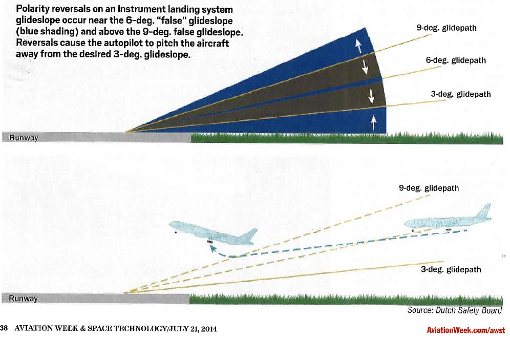
Traditional ILS systems are commonly known to have false capture indications for the pilot who does not cross check effectively. AW&ST July 24, 2014 highlighted this dangerous scenario with a story titled “False Promises” page 38. NASA has logged 57 occurrences of false glide slope capture. According to the AW&ST story, the Dutch Safety Board characterizes the issue as a “significant threat” to aviation safety.
An example in the NASA database:
Narrative: We were turned onto the ILS for runway 28. Intercepted the localizer. After we were established on the localizer the glide slope signal falsely captured the glide slope approximately 3 miles prior to where it should have. This led to a low altitude alert from ATC. The aircraft was flown to ZZZ later in the day where the localizer/GS function worked fine. Supplemental information from ACN 813477: approach descended us to 2500 ft just outside of WILLT. We captured a false glide slope and stated descending. At 2000 ft I realized we were on a false glide slope and as I was informing my copilot to level off ATC issued us a low altitude alert. We climbed back to 2200 ft. We reset our flight directors and intercepted the true glide slope. First time in 37 years of flying that I encountered this. Contradictory flight guidance is harder to resolve than it seems.
Another example in the NASA database:
Narrative: We were on vectors to intercept dal runway 31R localizer at assigned 2;400 ft MSL. The autopilot was engaged. We intercepted the localizer with a tailwind and aggressive angle of intercept (late turn by ATC; in my opinion). The pilot flying selected appch mode and the localizer captured; but overshot into the approach corridor for runway 31L. Simultaneously; the avionics indicated a glideslope capture. Position was 10 NM final and since we were 1;100 ft below the glideslope beam; the aircraft pitched up about 5 degrees and began a climb. I directed the pilot flying to disconnect the autopilot; that a ‘false glideslope had been captured.’ by the time he did this the aircraft was 600 ft high (3;000 ft MSL) and flying towards runway 31L. I told the pilot flying to descend back down to 2;400 ft and turn right towards the ILS 31R. I estimate our deviation time from 2;400 ft MSL and the 31R localizer to be 45 seconds. No TCAS warnings or ATC query were made. I know of no conflicts to other traffic. The 31R localizer and glideslope were recaptured and a normal approach and landing occurred.my opinion is that the glideslope signal on our landing runway (31R) fluctuated – perhaps due to aircraft taxiing through the critical zone. I recall seeing the glideslope pop down (case break) and then go back up off the HSI. I believe the avionics captured this signal and the aircraft pitched up to maintain the glideslope (even though we were 1;000+ ft below the normal glide path). I will keep a vigilant watch for false captures of the glideslope on dal 31R. Other pilots familiar with this airport report past fluctuations of this glideslope.
The same problem exists on the ILS localizer, false captures are possible at multiple discreet angles from centerline.
Many reports of localizer false captures are logged in the NASA database, for example:
Narrative: During the approach phase to STL we were given a heading to intercept the localizer for the ILS 30L. While we were on the heading (340; intercepting from the south via the qball arrival) we captured a ‘false’ localizer twice before intercepting the proper one. We knew it was an issue when the FMS display indicated our distance as approximately 12 miles from the approach course and then again about 5 miles from the approach course. The local cities (we could see visually straight down) we were over around Dupo; Illinois and then again over Sauget; Illinois. We reported it to ATC and they queried an air carrier following us. They reported nothing unusual. I have seen this happen once before on a visual approach but never in IMC conditions. It is quite unsafe and would easily fool someone who is not intimately familiar with the area and the approaches at STL. Both times the aircraft was taken out of the navigation mode to keep it from following the incorrect localizer. I have heard from other pilots that they have experienced this as well. I cannot determine if it is a problem with our avionics on the E145. This should be investigated by the FAA. A clearance for the approach closer to the actual localizer may prevent further ‘false captures.’
The TLS provides solutions to both of the above anomalies. The quantity and spacing of the TLS antennas were designed specifically to guarantee that the phase cycle is selected properly for the horizontal measurement subsystem known as the Azimuth Sensor Assembly (ASA).
For the elevation subsystem, as outlined in the Aviation Week & Space Technology article mentioned above, a traditional ILS can provide “false captures” on any cycle of 3 degrees. So this means that for an aircraft approaching an ILS at close to a 6 degree angle, a false capture of the glideslope can occur and erroneous vertical guidance is the dangerous result.
For the TLS, the operational concept is the same as for ILS and the pilot should intercept the glide slope from below. TLS was designed to have the standard ILS horizon of 7 degree service volume. By design there is no phase ambiguity from the horizon to 7 degrees. This eliminates the “false capture” conditions of a traditional ILS. This unique TLS design is also an advantage under certain environmental scenarios because the service volume is programmatically flexible. At one TLS site where the terrain slopes down, the calibration of the system was configured to operate from -1 to 6 degrees.
False captures from above the elevation service volume are also a concern for traditional ILS. Another advantage of ANPC’s design of the TLS includes using Mode C from the aircraft if available to remove glide slope indications when the aircraft is above 7 degrees elevation, when the aircraft is intercepting the glide slope from steep angle above. Otherwise, guidance will be transmitted just as with an ILS. TLS has been used with hundreds of sorties of fighter aircraft intercepting the TLS glideslope from above. This is not a good practice and can have very negative results on a traditional ILS because of the risk of false capture.
The TLS design has mitigated these issues.
References:
http://aviationweek.com/aviation-week-space-technology
http://asrs.arc.nasa.gov/